10 October 2015

Extreme low water on the Danube 2015


This year's hot summer combined with lack of precipitation have brought extreme low water levels on the Danube river. The blog asked its readers to send pictures if they found something interesting emerging from the riverbed, or they only find the landscape different from the usual. It looks like the low water will last well into autumn and with the drained catchment area we have to prepare for even lower water levels. 

Lowest water level measured at Budapest in 2015.


According to the summer forecasts the level of the Danube was far from the lowest value ever measured, but we advised not to leave our camera at home. During September and October the water level fell steadily to the value of 63 cm at Budapest which is only 12 cm above the lowest. 

But why are we interested in shallow water? - usually the floods draw more public attention. In times of low water Danubian depths reveals itself. Sand and gravel bars, holes in the riverbed, dykes etc. But while walking on the riverbanks you might find wrecks of ships, artifacts sunk long ago. The diving archaeologists are happy, they can work without their work-clothes. Europe's largest river shows us a different perspective, rather a desert than a river. 

There are also those who are not quite happy with low water. For example those shipmen who can not work for weeks in this situation. Or the environmentalists who are unable to help when they see tons of dying fish and shell in the drying river arms. 

So far the lowest value in Budapest ha been observed in 1947, 6th of November.  This was 51 cm. At the Vác gauging station it was -45 cm on the 29th of August. This is not a typo, the water level can go below the lowest point of the gauging station, then they have to extend it downwards. Unfortunately this is not a rare occurrence. 

If you happen to wander the banks of the Danube, do not forget to take pictures of the most interesting sights, and please send them (with the place, time and date) to our email address of facebook site

These are the received pictures so far (from earliest to latest): 

Jendricsné Vörös Dóra: Riverbank at Kisoroszi, 2015.07.17. 18:30 Budapest water level: 160 cm

Kurdi Imre: Felsőgöd beach. 2015.07.19. Budapest water level: 147 cm

Zirig Árpád: Mouth of the Morgó creek, Verőce 2015.07.22. 20:00 Budapest water level: 138 cm

Zirig Árpád: Mouth of the Morgó creek, Verőce 2015.07.22. 20:00 Budapest water level: 138 cm
  
Horváth Tibor: Alsógöd, volcanic tuff breaking the water. 2015.07.23. 22:30 Budapest water level: 139 cm 

Riverbank beneath the stone wall in Verőce.  2015.07.25. 17:00. Budapest water level: 139 cm 

Riverbank beneath the stone wall in Verőce.  2015.07.25. 17:00 Budapest water level: 139 cm 

Horváth Tibor: Alsógöd, volcanic tuff breaking the water. 2015.07.26. 9:40 PM. Budapest water level: 137 cm

 Szilágyi Csilla: Inn, Duna, Ilz - Passau: 2015.07.26.

Cigány sandbank, Mohács

Kurdi Imre: Sződliget 2015.07.28. Budapest water level: 135 cm

Kurdi Imre: Sződliget, mouth of the Sződi creek. 2015.07.28. Budapest water level: 135 cm

 Alsógöd beach, 2015 08.01. 9:00 Budapest water level: 139 cm

Oligocene clay in Alsógöd

  Dunakeszi ferry 2015.08.01. 9:30 Budapest water level: 139 cm

Mouth of the Csurgó creek in Dunakeszi. 2015.08.01. 9:30 Budapest water level: 139 cm

Gödi Island, dam. 2015.08.01. 15:30 Budapest water level: 147 cm

Gödi Island northern side 2015.08.01. 15:30 Budapest water level: 147 cm

 Kovács Miklós: Kacsa Island, Pócsmegyer 2015.08.05. Budapest water level: 145 cm

Kovács Miklós: Kacsa Island, Pócsmegyer 2015.08.05. Budapest water level: 145 cm

Kovács Miklós: Római-part, Budapest 2015.08.05. Budapest water level: 145 cm

Kovács Miklós: Inlet of the Palotai Island in Budapest 2015.08.05. Budapest water level: 145 cm

Wirker Károly: Süttő, Sandbanks near Madár Island 2015.08.11.

Sziget festival, Óbudai Island northern side 2015.08.13.

Schmidt Ádám József: Mouth of the Ördögárok in Budapest 2015.08.13. 10-11 AM Budapest water level: 107 cm

Vessző Katalin: Római part, Budapest 2015.08.14. morning. Budapest water level: 113 cm
   
Vessző Katalin: Római part, Budapest 2015.08.14. morning. Budapest water level: 113 cm

Vessző Katalin: Római part, Budapest 2015.08.14. morning. Budapest water level: 113 cm

Vessző Katalin: Gravel bar at Szentendre 2015.08.14. afternoon. Budapest water level: 114 cm


Kürti Gábor Dezső: Helembai gravel bar 2015.08.15. Budapest water level: 109 cm (Szob: w. l. -17 cm)

Tarr Dominik: Kis-Háros Island, Nagytétény 2015.08.16. 2-3 PM Budapest water level: 98 cm

Tarr Dominik: Kis-Háros Island, Nagytétény 2015.08.16. 2-3 PM Budapest water level: 98 cm

Becz Miklós: Dunaszekcső, riverbank full of loess cemented by calcium carbonate

Bucsek Tamás: Vác,  2015.09.20. evening. Budapest water level: 95 cm

 Horváth Tibor: Sand bar below the Megyeri bridge. 2015.09.22. Budapest water level: 76 cm 


Horváth Tibor: Alsógöd, the volcanic tuff outcrops in the Danube. 2015.09.22. Budapest water level: 76 cm 

Sand bar of the Szentendrei Island, 2015.10.04. Budapest water level: 72 cm

The Szobi and Helembai gravel bar, behind them the Helemba Island. 2015.10.05. Budapest water level: 67 cm

05 October 2015

Qualifying round of the "Danubian Island of the year 2015" voting


We have fourteen nominated island this year for the qualifying rounds, four more than last year. So there will be a great variety of Danubian islands to select your favourite from. You might find the second and third island from last year's finalists, and what's more, there is the winner on the below picture altogether with a new nominee. Also, we have an island outside Hungary, the famous Liberland.
Last year we had a sum of 436 votes in the qualifying rounds, this year we hope there will be more. Remember, only the first two island qualifies into the finals. There will be anothre island added by the Donauinslen blog. This voting ends midnight, October 12th 2015. The finals will begin next evening!


So here are the nominated islands for 2015, please select your favourite:


The Zebegényi and the Kismarosi Island have been qualified! Congratulations!

The final results as of 2015.10.13. 0:01

10 September 2015

Nominate your favourites for the "Danubian Island of the year" voting!

Since the Danubian Islands have no chance to entry themselves, we would like to ask our readers to do this favour for their favourite islands, until the 5th October 2015!


You might go in for the last year's winners, but they will not participate in the final voting. The reason is simple; let others win, and there are many interesting islands on the Danube worthy for learning about them worldwide.

There might be a change in the voting application this year, but the rules will be the same as last year: in the finals the blog's entry will race with the two with the most votes. Last year the Donauinseln blog's entry matched with the will of the voters, that is why the Veránka Island of Érsekcsanád became the third entry. The got the second place in 2014, this year there is a chance to be the first!

The qualifying round will take place between all entries from 5-12th October. The finals will be held from 13th October till 31th December. The results will be published in the last post of the year.  

Please write your entries here below or on our Facebook page as a comment. When nominating your favourite islands, comments for the reason are highly appreciated!

Until this time there were two winners both form Hungary:

2015. ? :)

13 July 2015

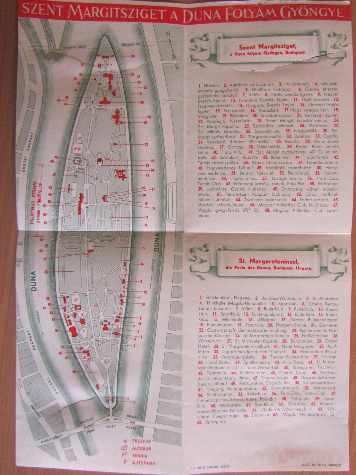
Perspective sight of the St. Margaret Island


This is how the Margaret Island looked like from above, in 1963. 


This image was originally entitled as "Budapest Távlati Térképe" (Perspective sight of Budapest) and published in 1963. A friend of mine asked for this map, when I noticed the Margaret Island. It was hand drawn by István Mácsai and János Kiss. If we look at it closer we may not find the Danubius Health Spa Hotel next to the Grand Hotel in the left tip of the island, it hasn't built yet. Many old buildings and other architecture vanished during the fierce fighting in January, 1945 when the Soviet forces bombed the island. We can see the remaining monuments, like the Musical Well, the Grand Hotel, the famous water tower and open-air theatre, the Rose garden, the Palatinus baths, the Hajós Alfréd swimming pool. It is worth to compare this image with the below one, drawn 24 years after the first one.


The road between the two bridges, across the island marks the old riverbank. In the beginning of the 20th century the Buda side and the southern tip of the island has been enlarged. In 1945 the park island of Budapest has been devastated, many of the buildings has been destroyed and later demolished instead of rebuilding. For example the summer cottage of Palatine Joseph together with the 1838 icy flood mark, the pavilion of the main entrance, the Island Café, the MAC clubhouse, the Saint Margaret Chapel, the Dairy Shop and many more buildings. At least we have the old maps and pictures of the island which has never regained its former beauty.   


Here you can see those buildings disappeared after World War II.

Here you can see how would it looked like nowadays

21 June 2015

Danubian Notgeld


Years after the First World War in Middle Europe were anarchic.  In the defeated Germany and the new countries like Austria and Hungary often the local authorities had to take care of state responsibilities. The weakened central power did not and could not guarantee public safety, organization of transport, and our main topic the currency issues. But what has the currency do with the Danube? Let's have a look at the below picture.

Donauschleife = Schlögener Schlinge

In Austria, the first Notgelds were issued on the summer of 1919. in Innsbruck, Tyrol. The Notgeld had been issued by authorities, which had no right for issuing currency in cases of emergency, like a siege, war, economic crisis and any other event causing disruption of the cash flow. They are mostly banknotes, but we have knowledge of coins and stamps as well. The material is mostly paper and metal, but it can be almost anything like leather and sulphur as well. 

Well the three years in Austria between the summer of 1919 and October of 1921 brought the heavens for the banknote collectors. After Innsbruck came Kitzbühel, then Kufstein, Vorarlberg, Salzburg started to issue their own Notgeld. Then followed by the capital Vienna. But the most Notgeld was issued in Upper-Austria in the year 1920. 425 out of the province's villages had their own money and they were valid until 1921, when the economical and political situation has been settled. 

Colorful Neuhaus

Upper-Austria is situated along the Danube and many of these settlements had their own Notgeld with unified design. All of the settlements put their own most beautiful Danubian view on their banknote series. They all had a Gothic script with the title "Donautal Notgeld" which means Danube valley necessity money. Underneath this there was a Danubian image of a specific landscape and the name of the settlemet also with Gothic letters. On the sides there was a tendril ornament connecting the upper and lower part. 

Notgelds with different syles and integrated color.

On the back side there was a general script with only changing the name of the settlement and its major. It had the following label in German:

Die Gemeinde ... haftet für die Verbindlichkeit der Einlösung. Einlösung nach erfolgter Kundmachung. Der Bürgermeister ... Nachahmung wird gesetzlich bestraft 

I. e.: The community ... is liable for the obligation of cashing. Cashing after promulgation. Major ... Banknote counterfeiting is forbidden.

Community Vichtenstein

Community St. Aegidi

Community Ran(n)ariedl

The Danube valley Notgelds were issued in many denominations and colours, moreover they lived to have many editions, like the one on the first image. There stands 3. Aufgabe - 3rd edition. Maybe only the collectors can tell how many settlements issued this kind of necessity money and how many variations did the Danubian Notgeld had. 

There was a vast amount of these Notgelds circulating in the Upper-Austrian province. These can be bought up to now from collectors, antique shops all over in Middle Europe. Both online and offline.  

02 June 2015

Fotograf nádherných miest - rozhovor s fotografom Martinom Kápostášom


Dávno som si často lámal hlavu nad tým, ako sa dá rozlíšiť na fotke západ slnka od východu. V neznámom kraji je to takmer nemožné. Našťastie na týchto známych, prekrásných miestach ako Ostrihom, Hideglelőskereszt, Visegrád, Dömös a Pilis, alebo v kopcoch v Chľabe (Burda), toto nie je ťažkou úlohou. Kto pozná dunajskú zákrutu, takto ju ešte určite nevidel, ako táto krajina ožije na fotkách štúrovského fotografa Martina Kápostáša. Požiadali sme o rozhovor a dostali sme ho, aby sme mohli predstaviť rieku z pohľadu fotografa. Napokon vyjde najavo aj to, či je na fotkách východ alebo západ slnka :)


02 April 2015

Agonia insulei Ada Kaleh


Zilele trecute, ziarul Adevarul a publicat fotografiile lui Mejdi Ibrahim despre ultimele clipe ale insulei Ada Kaleh. Sunt fotografii apasatoare. Pe langa cladirile demolate sau in curs de demolare, din care se salveaza  materiale de constructie refolosibile, stau muncitori si soldati. Case goale, cu geamuri scoase stau si privesc ulitele depopulate. Au disparut turcii cu tot cu pipe, turbane si dulceturi de trandafir. Inainte de a se ridica nivelul apei s-a lichidat cimitirul, s-au demolat case seculare. Am reusit sa luam legatura si cu un insular vorbitor de limba maghiara. Adele Kehl-Geafer, in copilarie, isi petrecea verile pe insula si ne-a povestit despre ultima vizita din vara anului 1967.


27 March 2015

Todeskampf von Ada Kaleh


In jüngster Zeit hat die rumänische Zeitung Adevarul Ibrahim Medjis öfters Fotos über die letzte Zeitepoche der Insel Ada Kaleh veröffentlicht. Diese Bilder sind wie der Niedergang der Insel sehr deprimierend. Arbeiter, Soldaten stehen zwischen den abgerissenen Gebäuden, von denen sie alle Baustoffe gewonnen haben. Ausgeplünderten Gebäude, gähnende Leere der Fensterlosen Öffnungen starren auf die verlassenen Straßen. Die Türken verschwanden samt Rosenmarmelade, Pfeife und Turban. Die Friedhöfe wurden ausgegraben und in einem Massengrab „entsorgt”. Jahrhunderte alte Häuser wurden abgerissen, bevor die Flut alles verschlungen hat. Wir haben es geschafft, eine ungarischsprachige Inselbewohnerin zu kontaktieren. Als Kind verbrachte Adele Geafer ihre Sommer auf der Insel und hat für uns ihren letzten Besuch im Jahr 1967 verewigt.


Das genaue Datum der Überflutung konnte nicht erruiert werden. Das Wasserkraftwerk Eiserne Tor I. wurde 1972 in Betrieb gesetzt, aber die Überflutung dürfte bereits früher begonnen haben. Die Bilder zeigen den Prozess der Zerstörung von Häusern, bis an den Punkt, an dem von einer Insel kaum mehr was zu sehen war. Es ist daher sehr wahrscheinlich, dass einige der Bilder 1971, während die letzten 1972 fotografiert wurden.

20 November 2014

The devil's bridge in Regensburg


There are two opinions why Regensburg is the northernmost settlement. First, its inhabitants say the ancient Ratisbon or Castra Regina looks like the northernmost Italian city. Second, the Danube reaches its northernmost point, latitude 49 next to this city. If we do not count emperor Traian’s bridge, the first permanent stone bridge was built here. There is a legend linked to its construction and also a Danubian island is connected to our story.


13 November 2014

Zwei Meere hat der Herzog verbunden


Der 1846 eingeweihte Ludwigskanal ist als der erste Kanal auf dem Kontinent in Erinnerung geblieben, der die Verbindung zwischen der Nordsee und dem Schwarzen Meer hergestellt hat. Weniger bekannt, dass es bereits 50 Jahre vorher einen Kanal gegeben hat, durch den die Nebenflüsse der Moldau (Vltava) und die Donau verbunden waren. Seine Spuren müssen wir jedoch nicht in Bayern, sondern im Böhmerwald suchen.


03 November 2014

Die Deutsche Donau


Immer wenn es Herbst wird, wenn im Wind schon der Geruch von welkem Laub und die feuchte Kühle von kommenden Nebeln zu ahnen sind, dann denke ich an die Donau im Süden des reiches, an ihre Auen mit dem silbrigen Glanz der Weidenbäume, an die Altwasser in den dunklen Tiefen des Erlengestrüpps und an die steilen Hänge der Wachau, zwischen denen das Wasser des Stromes nun klarer wird und schon hier und da ein wenig von dem Blau zeigt, das an den Abenden im Spätherbst alles mit seinem Leuchten erfüllt. 

Die Breg windet sich durch den Schwarzwald


29 October 2014

Ostrov Dunaja - 2014


Združenie ornitológov Madarska,od roku 1979 každý rok zvolý druh vtáka,týmto dopomáha k zaostreniu na tieto krásne a doležité tvory v našom okolí. Od roku 2007 lesnícké združenie Maďarska,usporadúva hlasovanie o titul-Strom roka. Medzi mladšie projekty patrí napríklad hlasovanie o rybu roka,toto hlasovanie rok čo rok vyhlasuje štátne združenie rybárov. Práve kvoly týmto trom mylím podujatiam,som sa rozhodol pomocť vtáčikom,aby si lahko našli miesto na pristátie,pomocť stromom aby mohly svoje koreňe rozpusťiť a rybám aby našli svoje útočiská. Vyhlasujeme projekt s názvom ostrov roka na Dunaji.


Hlasujťe na ostrov Dunaja - 2014!

Hlavným dovodom hlasovania,je aby sme čím viac a lepšie zpoznaly naše tajuplné zákutia rieky Dunaja. Majú toťiž /podla nás/ aspoň tolko krásy a zaujímavosti ako Seychelly a podobné oblúbené destinácie. Toho roku je to druhý krát,čo toto hlasovanie zverejňujeme,snažíme sa o to,aby sme vytvorily tradíciu pre nadšencov "domácej prírody"

Minulý rok našu súťaž vyhral ostrov Kompkoto kde v priebehu tochto roka už zahájily rehabilitáciu ostrova.

V roku 2014 sú na titul Ostrov roka nominované nasledovné miesta:

Ostrov Göd (Homoksziget), Göd

Je súčasťou národného parku Duna Ipoly.


Ostrov Helemba (Helembasziget), Esztergom-Búbánatvölgy

Je ťiež súčasťou národného parku Duna-Ipoly


Ostrov Veránka, Érsekcsanád

Nachádza sa v národnom parku Duna-Dráva


Hlasovať je možné do 31 decembra 2014.

31 May 2014

Le pietre di Bölcske

MAGYARUL

scritto da Gergely Schell
 
Bölcske e Madocsa sono due comuni sulle sponde del Danubio, entrambi tra le città di Dunaföldvár e Paks. La ferrovia (che ai giorni d’oggi non svolge trasporto pubblico), e l’autostrada (oggigiorni meno in uso per via della strada numero 6), entrambi sono abbastanza distanti, dunque preservano l’isolamento dei villaggi. Gli storici, archeologi, antropologi, etnografici ed altri numerosi intenditori fanno tesoro di questi siti, per cui ne vale la pena di assentarsi dalla via maestra.


01 May 2014

Revitalization of the Wienfluss


19th-century urban development involved the development of sewerage. Until then, the rivers were the main collectors, and the smaller streams served as channels. The Ördögárok stream in Buda, and the Rákos stream in Pest exuded unbearable stench before being eradicated. The second capital of the Austro-Hungarian Monarchy partly buried, partly forced underground the putrid channels which emanated putrid stench and usually also served as garbage dumps. Few people know that at that time the capital of the Monarchy also faced similar problems. There a firm and drastic intervention was necessary because of the floods and disease risk of the Wien river, which gave the name of the city. 

The Wien river being covered, ca. 1895.

The rapid improvement of the water quality after the installation of sewerage confronted Vienna city planning with new challenges. The river is no longer considered an enemy, and they slowly take the first step to the figurative and literal rehabilitation of the Wien river. The river, which not only gave the name of the city, but during its history also defended it from the enemy.

The case of the chicken and the egg – Which Wien was before?


The name of Wien was first used in the Salzburg Yearbooks of 881, in the form “ad Uueniam” (ad Weniam), but it is not clear whether it refers to the city or to the river. In Lower Austria it is quite frequent that a settlement along the Danube is named for the local tributary river (e.g. Enns, Ybbs, Aggsbach etc.), thus historians and etymologists think it likely that Vienna was named after the Wien river.

The Wien river as the natural line of defense of Vindobona

The river had a special importance for the development and progression of Vienna. It played a strategic role in the city’s southeast line of defense. In ancient times the legionary camp of Vindobona was surrounded on two sides by the Wien river and the Ottakring creek, forming two natural ditches around the settlement. In Roman times, the ramose side-branches of the Danube created a veritable archipelago on the widening floodplain, and the Wien poured into one of these branches.

The mouth of the Wien river (right), and the city walls of Vienna in 1686

Just like in Csallóköz – the Schüttinsel to the south of Bratislava/Pozsony/Preßburg –, the main branch of the Danube in Vienna was not suitable for navigation. The Donaukanal known today started to take shape in the Middle Ages from a side branch of the Danube, where the sailors could approach the imperial city, like they did on the Moson branch of the Danube in the Hungarian section. The Wien poured into the Danube at the easternmost bastion of the city, where above its mouth it formed a section of the moat called Graben.

The river bed before regulation

30 April 2014

Ulmer Schachtel

MAGYARUL

"Die ersten fanden den Tod,
die zweiten hatten die Not,
und die dritten erst das Brot."

Ulmer Schachtel auf dem Weg nach Plintenburg


27 April 2014

A view on Pressburg


The members of the German ethnic minority ousted from Slovakia could have not found a better site for their memorial than the hill of Braunsberg, rising on the Austrian side of the “Porta Hungarica”. A particularly funny fact is that this is one of the favorite Austrian site of excursion of the inhabitants of Bratislava, a point with a great view on their capital. Those who want to take the best picture of Lamač/Lamacs/Blumenau, Devín/Dévény/Theben, the Kamzík/Zerge-hegy/Gemsenberg, or the castle hill of Bratislava/Pozsony/Pressburg, must climb up to the memorial. With many Slovaks already the name “Felvidék” (Upper Region), the historical Hungarian name of their country beats off the fuse. What will they think about the country of “Nordkarpatelnand” and its German-speaking cities?

A view on Preßburg

07 April 2014

Lost islands of Budapest


Once a friend of mine, who is a history-geography teacher just like me, told me there was a competition in their school. One of the questions was: How many Danubian islands are there in Budapest? He told me what he tought the correct answer would be, which was an irrationally big number, and asked me if it is true. I told him: it depends. What do you call an island? 

In my opinion, island is a peace of land, which is completely surrounded by a body of water all the time. Not just a few months of the year, but the whole year. I told my friend, there are a very few islands in Budapest meeting this criteria. 

We have to wind back the clock till the dawn of written history. By the Budapest section it means the time when the first Roman legionaries settled down next to the Danuvios river. Until this time there was no human impact on the Danube valley. No dredging, no locks, no stone embankments and no bridges.

17 March 2014

Disappearing high-water marks in Budapest

MAGYARUL

"And shall your children ask ye tomorrow  
what this stone is in your temple,  
thus shall ye say unto them:  
Let the last generation hear  
that the waters of the Danube reached this high.."  
   

The last comprehensive study on the high-water marks of Budapest was completed in 1977. György Rajna’s “Flood tables in Budapest” was published only two years later, in 1979, in the 21st volume of Tanulmányok Budapest Múltjából (Studies from the Past of Budapest). This short span of time was enough to force the author to add a short addendum, that during these two years two flood tables of 1838 disappeared from two buildings in Ferencváros, and two other were demolished together with the house in Újpest. 35 years have passed since the publication of this study. What has been the fate of the carefully collected and documented tables? This is what I tried to survey. 

A nice example of the rescue of a flood table: Ferencváros, Bokréta utca 32.